Best GIS Software
Best GIS software includes Mango, Maptitude, ArcGIS, Maptive, and LandVision. This software provides a foundation for mapping and analysis and helps users understand patterns, relationships, and geographic context.


No Cost Personal Advisor
List of 20 Best GIS Software
Emergents | 2024
Interactive web maps for SMB, non-profits, local government
Mango is a GIS software used by local government and various other non-profit organizations. It is one of the best GIS software for transforming data into interactive web pages. This software is used to empower communities, colleagues, and clients. Learn more about Mango
Explore various Mango features, compare the pricing plans, and unlock the potential of seamless operations by selecting the right software for your business.
Features
View all Mango Features- Geocoding
- Color Coding
- Census Data Integration
- Map Creation
- Labeling
- Map Sharing
- Spatial Analysis
- Image Exporting
Mango Caters to
- StartUps
- SMBs
- Agencies
- Enterprises
Emergents | 2024
Geographic Information System for businesses and enterprises
Maptitude is a geographic information system software that is loaded with all kinds of features and capabilities, like maps and demographic data of users. This software provides other features like Data Linking and Updating, Logistics, and Site Selection. Learn more about Maptitude
Explore various Maptitude features, compare the pricing plans, and unlock the potential of seamless operations by selecting the right software for your business.
Features
View all Maptitude Features- Image Management
- Internet Mapping
- Geocoding
- Map Creation
- Data Visualization
- Census Data Integration
- Spatial Analysis
- Map Sharing
Maptitude Caters to
- StartUps
- SMBs
- Agencies
- Enterprises
Emergents | 2024
Cartography and visualization features for user demographics
ArcGIS is a geographic information system GIS software that provides advanced cartography and visualization features. This geographic information software offers beautiful cartography and 2-D & 3-D maps, along with analytics and data science features. Read ArcGIS Reviews
Explore various ArcGIS features, compare the pricing plans, and unlock the potential of seamless operations by selecting the right software for your business.
Features
View all ArcGIS Features- Geofencing
- Multiple Route Support
- Dispatching
- Scheduling
- For Healthcare
- Geocoding
- Interoperability
- Paratransit Management
ArcGIS Caters to
- StartUps
- SMBs
- Agencies
- Enterprises
Contenders | 2024
Powerful Map Tools for customization and analysis
Maptive is a GIS software that allows users to customize their maps with a plethora of settings and map tools. This software offers various features like Filter Tool, Draw Radius on Map, Drive Time Polygons, Route Optimization, and Create Sales Territories. Read Maptive Reviews
Explore various Maptive features, compare the pricing plans, and unlock the potential of seamless operations by selecting the right software for your business.
Features
View all Maptive Features- Geocoding
- Location Tracking
- Demographic Data
- Data Visualization
Maptive Caters to
- StartUps
- SMBs
- Agencies
- Enterprises
Emergents | 2024
Cloud-based mapping platform for real estate professionals
LandVision is one of the best GIS software geographic information system software government agencies, real estate brokers, underwriters, and home builders. This cloud-based software offers comprehensive property research and analysis to make better decisions. Learn more about LandVision
Explore various LandVision features, compare the pricing plans, and unlock the potential of seamless operations by selecting the right software for your business.
Features
View all LandVision Features- Geocoding
- Image Management
- Census Data Integration
- Color Coding
- Map Creation
- Image Exporting
- Map Sharing
- 3D Imagery
LandVision Caters to
- StartUps
- SMBs
- Agencies
- Enterprises
Emergents | 2024
Business mapping software managing geographically data
Map Business Online is a geographic information system GIS software used by various companies and organizations for the geographical analysis of their business data. This GIS software offers advanced map design & visualization features for various purposes. Learn more about Map Business Online
Explore various Map Business Online features, compare the pricing plans, and unlock the potential of seamless operations by selecting the right software for your business.
- Field Sales Management
- Territorial Mapping
- Opportunity Management
- Referral Tracking
- Channel Management
- Call Management
- Contact Management
- Territory Management
Map Business Online Caters to
- StartUps
- SMBs
- Agencies
- Enterprises
Emergents | 2024
Comprehensive Mapping Solution for Business Transformation
eSpatial is a comprehensive geographic information software used by organizations and enterprises to transform their data into maps quickly. This cloud-based GIS software offers interactive visualization of maps and proximity analysis for new opportunities. Learn more about eSpatial
Explore various eSpatial features, compare the pricing plans, and unlock the potential of seamless operations by selecting the right software for your business.
Features
View all eSpatial Features- Embeddable Maps
- Field Sales Management
- Territory Management
- Color Coding
- Geocoding
- For Sales
- Map Sharing
- Interoperability
eSpatial Caters to
- StartUps
- SMBs
- Agencies
- Enterprises
Contenders | 2024
Easy-to-use desktop GIS solution for business analysts
MapInfo Pro is one of the best GIS software offering fast, simple, and powerful desktop GIS solutions. This software allows its users to analyze and work upon various mapping data to make important decisions. It is used in insurance and Telco industries. Read MapInfo Pro Reviews
Explore various MapInfo Pro features, compare the pricing plans, and unlock the potential of seamless operations by selecting the right software for your business.
Features
View all MapInfo Pro Features- Internet Mapping
- Geocoding
- Map Sharing
- Spatial Analysis
MapInfo Pro Caters to
- StartUps
- SMBs
- Agencies
- Enterprises
Emergents | 2024
Dynamic GIS mapping software for geographic information
Geomedia is a geographic information system software that provides powerful analytical tools and clear symbolization. This geographic information system GIS software offers superior data access, sophisticated & dynamic analysis, and spatial modeler Geomedia. Learn more about GeoMedia
Explore various GeoMedia features, compare the pricing plans, and unlock the potential of seamless operations by selecting the right software for your business.
Features
View all GeoMedia Features- Image Management
- Image Exporting
- Geocoding
- Spatial Analysis
- Internet Mapping
- Map Sharing
- 3D Imagery
- Map Creation
GeoMedia Caters to
- StartUps
- SMBs
- Agencies
- Enterprises
Emergents | 2024
Territory mapping and geography software for analysis
Tactician is a geographic information software used by businesses for the analysis using features like territory mapping. This GIS software offers functionalities like Color Coding and is supported on Windows only. It also offers business hours of support. Learn more about Tactician
Explore various Tactician features, compare the pricing plans, and unlock the potential of seamless operations by selecting the right software for your business.
Features
View all Tactician Features- Color Coding
Tactician Caters to
- StartUps
- SMBs
- Agencies
- Enterprises
Emergents | 2024
Compression and Manipulation of High-Resolution imagery
GeoExpress is a GIS software that is used to shrink geospatial data and image files to up to 5 percent of the original size. This geographic information system software offers image customization, integration of imagery assets, and image compression features. Learn more about GeoExpress
Explore various GeoExpress features, compare the pricing plans, and unlock the potential of seamless operations by selecting the right software for your business.
Features
View all GeoExpress Features- Image Exporting
- Interoperability
- Spatial Analysis
- Image Management
GeoExpress Caters to
- StartUps
- SMBs
- Agencies
- Enterprises
Emergents | 2024
Simple & productive platform for efficient data collection
TerraSync is a reliable geographic information system GIS software designed for easy and quick data collection and maintenance. This software offers simple and efficient tools for high-quality data regardless of the complexity of the GIS information. Learn more about TerraSync
Explore various TerraSync features, compare the pricing plans, and unlock the potential of seamless operations by selecting the right software for your business.
Features
View all TerraSync Features- Geocoding
- Spatial Analysis
- GIS
- Internet Mapping
- Map Creation
TerraSync Caters to
- StartUps
- SMBs
- Agencies
- Enterprises
Emergents | 2024
Cloud-based portal for flexible & efficient geographic data
SuperMap is a cloud-based GIS software that provides distributed spatial analysis tools for density analysis, point aggregation, and trajectory reconstruction. This geographic information software offers custom support & text styles and text & picture view. Learn more about SuperMap
Explore various SuperMap features, compare the pricing plans, and unlock the potential of seamless operations by selecting the right software for your business.
Features
View all SuperMap Features- Map Sharing
- Map Creation
- 3D Imagery
SuperMap Caters to
- StartUps
- SMBs
- Agencies
- Enterprises
Contenders | 2024
Gis
FuseGIS is a SaaS solution with one subscription plan for full-access, priced at $50 monthly, per user. All subscribers get a no-questions 30-day money back guarantee, effectively giving users a one month free trial. FuseGIS is regularly updated, with new data layers. Read FuseGis Reviews
Explore various FuseGis features, compare the pricing plans, and unlock the potential of seamless operations by selecting the right software for your business.
Features
View all FuseGis Features- Injury Reporting
- Attendance management
- Auditing
- Interoperability
- Field Sales Management
- Sales Forecasting
- Image Management
- Employee Management
FuseGis Caters to
- StartUps
- SMBs
- Agencies
- Enterprises
Software by Shivrai Technologies Pvt. Ltd
A complete resource-planning multi-user software suite for managing multiple farms. It is helps in input management, HR management, production, financial and marketing management of any farm. Read FarmERP Reviews
Explore various FarmERP features, compare the pricing plans, and unlock the potential of seamless operations by selecting the right software for your business.
FarmERP Caters to
- StartUps
- SMBs
- Agencies
- Enterprises
Software by LUCIAD
LUCIAD is a fully featured Gis Software designed to serve Enterprises, Agencies. LUCIAD provides end-to-end solutions designed for Windows. This online Gis system offers Census Data Integration, Color Coding, Image Management, 3D Imagery, Interoperability at one place. Read LUCIAD Reviews
Explore various LUCIAD features, compare the pricing plans, and unlock the potential of seamless operations by selecting the right software for your business.
Features
View all LUCIAD Features- Color Coding
- Census Data Integration
- Spatial Analysis
- 3D Imagery
- Map Sharing
- Image Management
- Geocoding
- Image Exporting
LUCIAD Caters to
- StartUps
- SMBs
- Agencies
- Enterprises
Software by Tetrad Computer Applications
ESRI ArcView is a fully featured Gis Software designed to serve SMEs, Agencies. ESRI ArcView provides end-to-end solutions designed for Windows. This online Gis system offers Internet Mapping, Map Creation at one place. Learn more about ESRI ArcView
Explore various ESRI ArcView features, compare the pricing plans, and unlock the potential of seamless operations by selecting the right software for your business.
Features
View all ESRI ArcView Features- Map Creation
- Internet Mapping
ESRI ArcView Caters to
- StartUps
- SMBs
- Agencies
- Enterprises
Emergents | 2024
Software by Golden Software Technologies
MapViewer is a fully featured Gis Software designed to serve Enterprises, SMEs. MapViewer provides end-to-end solutions designed for Windows. This online Gis system offers Spatial Analysis, Image Exporting, Map Creation, Geocoding, Image Management at one place. Learn more about MapViewer
Explore various MapViewer features, compare the pricing plans, and unlock the potential of seamless operations by selecting the right software for your business.
Features
View all MapViewer Features- Image Exporting
- Image Management
- Geocoding
- Labeling
- Spatial Analysis
- Map Creation
MapViewer Caters to
- StartUps
- SMBs
- Agencies
- Enterprises
Software by Harris Geospatial Solutions
ENVI is a fully featured Gis Software designed to serve SMEs, Startups. ENVI provides end-to-end solutions designed for Windows. This online Gis system offers Color Coding, Image Exporting, Image Management, Map Creation at one place. Learn more about ENVI
Explore various ENVI features, compare the pricing plans, and unlock the potential of seamless operations by selecting the right software for your business.
Features
View all ENVI Features- Image Exporting
- Color Coding
- Map Creation
- Image Management
ENVI Caters to
- StartUps
- SMBs
- Agencies
- Enterprises
Software by Halliburton
PEOffice is a fully featured Gis Software designed to serve SMEs, Agencies. PEOffice provides end-to-end solutions designed for Web App. This online Gis system offers at one place. Learn more about PEOffice
Explore various PEOffice features, compare the pricing plans, and unlock the potential of seamless operations by selecting the right software for your business.
PEOffice Caters to
- StartUps
- SMBs
- Agencies
- Enterprises
Get Free Expert Advice

Recent Review
What is GIS Mapping Software?
A Geographic Information System (GIS Software) is designed to store, retrieve, manage, display, and analyze all types of geographic and spatial data. GIS software can produce maps and other graphic displays of geographic information for analysis and presentation.
GIS mapping software is used to develop maps and other geographic information for presentation and analysis purposes. It stores data based on geographical features and characteristics. Thus, it helps visualize the geographic and spatial data for input to the organization’s different systems.
It can be featured using points, lines, and areas. For example, aerial photos can be used as raster images, road data can be stored as lines, boundaries can be stored as areas, and city data can be stored as points.
It grasps the information using spatial indices like longitude, latitude, etc. Thus, no matter how descriptive any data is, there is always the correct identification of the features using this mapping software.
GIS mapping software can be used as a data visualization tool and helps in problem-solving and decision-making in any organization. It can help you map locations, quantities, densities, changes, nearby areas, and inside a specific location.
It incorporates technology to take the leverage of spatial data. It further works on business-based plans and methods for facilitating normal operations.
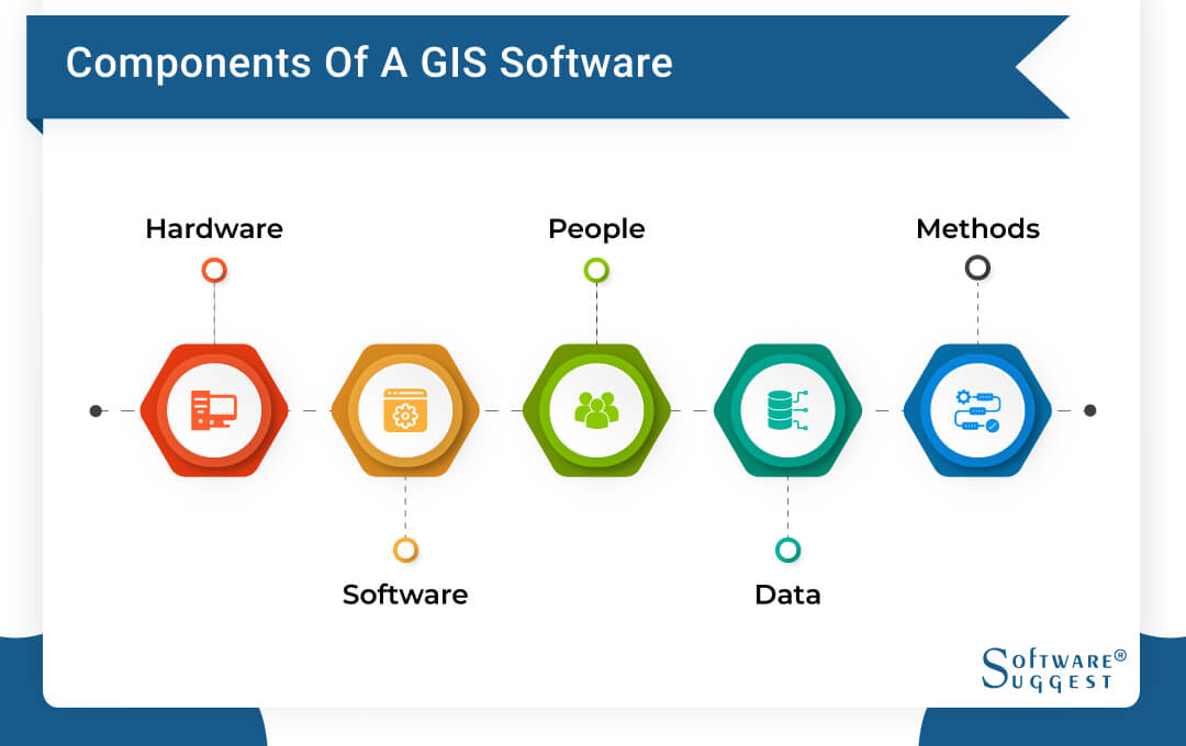
Before jumping to features, it is crucial to understand their main constituents. The critical components of a GIS geographic information system are:
1. Hardware
Geographic information software uses centralized computer servers or standalone desktop computers, or network configured computers.
2. Software
The software helps execute functions and tools to monitor the input and manipulation of geographic information. It also helps in the database management system and supports geographic query, visualization, and analysis. It is further responsible for a user-friendly interface.
3. People
The management of GEO information systems is carried out by trained professionals responsible for its maintenance as well.
4. Data
Spatial data and geographic data are managed by GIS software.
5. Methods
The method of operation of any GIS system is based on the company’s expectations. For example, a soil survey company and delivery company employ different GIS software solutions and practices to get the best out of it.
The 5 Best GIS Software for 2024
- Top-Rated GIS Software for Small Business: Mango
- Complete GIS Software for Advanced cartography: Maptitude
- Leading GIS Software for Business Owners: ArcGIS
- Best GIS Software in India: Maptive
- Best Indian GIS Software for Detailed Analysis: LandVision
Use of GIS Software
Different kinds of data management require specialized tools. But when it comes to spatial and geographic data, geographic information system (GIS) software is the ultimate solution. It is a conceptualized framework that allows data capture, data preparation, data management, storing and maintenance, etc.
Apart from these essential functions, it also enables data manipulation, data analysis, and data presentation. GIS tool is vital for any private organization or public sector dealing with any spatial or geographic data.
Roger F Tomlinson is regarded as the father of GIS as he coined the term “geographic information system” in the year 1968. He used the first-ever computerized GIS on the Canada Geographic Information System.
Since then, enormous developments have taken place in the GIS systems. Gaining actionable intelligence for all types of spatial and geographical data is the main aim of modern GIS tools. Ideally, this technology quickly revolves around the way of looking at maps and gathering information.
Organizations, whether the public or private sector, are dealing with dynamic data. Thus, physical tools like maps and images cannot deliver real-time intelligence that can be implemented in decision-making.
Take the example of a national census or soil distribution for any agricultural-based company. In both cases, geographical locations have an essential role. The same can’t be represented in excel sheets. Hence, the pace of geographic information systems software is gaining momentum. Let us have a deep understanding of this modern technology.
Features of Geographic Information Software
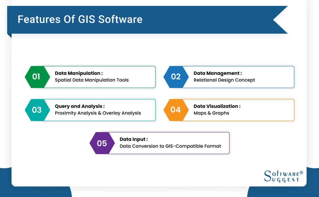
The information is stored in thematic layers in geographic information systems. The main features of this software include:
1. Data Input-Data Conversion to GIS-Compatible Format:
Raw geographical data can’t be fed to the GIS software. It needs to be converted into a digitized form. Thus, data input is the first feature of any GIS. It is done automatically with the help of scanning and digitizing tablets.
Further, you can take data from the data-supplying agencies in addition to the in-built GIS-compatible data. The different features of data input include geocoding, vector model, and raster method.
Geocoding is an automated process that creates geographic references for multiple locations from raw data like references. It is the building block of the GIS features like locating a business, locating a forest, etc.
The vector model uses the information regarding lines, polygons, and points encoded and stored as x, y, and z coordinates’ collections. It uses single x, and y coordinates for point location, point coordinates for linear features, and a loop of coordinates for polygonal elements. Thus, it is highly efficient for establishing discrete components in a GIS system.
On the other hand, the raster model constitutes a collection of grid cells. It can handle continuously changing features like population. Modern GIS is equipped with all these features.
2. Data Manipulation- Spatial Data Manipulation Tools:
Data manipulation is achieved using automated tools. Thus, the GIS software understands the need for regular scaling of different data that can be temporary or permanent based on the requirements. This manipulation further helps in eliminating unnecessary data from the system.
3. Data Management- Relational Design Concept:
Implementation of data management techniques requires strict and straightforward concepts. Thus, all modern online GIS software works on relational design. In relational design, data is stored as a collection of tables with standard fields getting linked together. Its key advantages are high scalability and flexibility.
4. Query and Analysis- Proximity Analysis and Overlay Analysis:
The best GIS system should be capable of handling analytical and straightforward questions. The point-and-click technology and sophisticated analysis tools are inseparable from a GIS. The proximity analysis and overlay analysis are the essential features of the query and analysis function.
Buffering is used to establish the proximity relationship between different articles of the query. It answers questions like how many customers live within 10km of the store and how many houses are located near this water source.
The data integration on joints, slopes, etc., requires overlay. It is achieved in layers and is more than a simple visual operation as it requires the physical joining of data layers. Thus, any GIS system should be powered by these two features.
5. Data Visualization- Maps and Graphs:
Maps and graphs mark the data visualization by GIS. These can be further integrated with three-dimensional views, multimedia, photographic images, and reports.
These are necessary features of any GIS software that stores and communicates geographical information. Modern GIS is equipped with multiple tools for cartographical representation.
Benefits of Using GIS Software
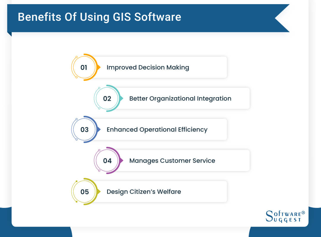
The significant benefits of using the GIS system in your organization are:
1. Improved Decision-Making:
Making a correct decision about your following business location is best realized by the GIS. It also helps with the real-time data that leads to improved decision-making at all organizational levels. The decisions like zoning, planning, and natural resources extraction are some of the critical functional areas.
2. Better Organizational Integration:
GIS software improves communication within the organization. The data visualization from GIS is helpful in storytelling and understanding the current situations. Thus, your valuable data can commute smoothly within the organization.
3. Enhanced Operational Efficiency:
GIS software solutions reduce operational costs and significantly enhance the existing functions. The automation of the delivery and tracking functions by GIS eliminates the loopholes in the system.
4. Manages Customer Service:
The geospatial data from the GIS system can work to manage your customer service. It further helps the companies to identify potential customers and serve them accordingly to improve their customer journey.
5. Design Citizen’s Welfare:
This is the best use of a geoinformation system for government or not-for-profit organizations. These organizations can focus on citizen welfare services by employing the latest GIS. It saves hundreds of dollars in collecting data, validating the inputs, and designing different locations’ strategies.
Considerations while Purchasing GIS Software
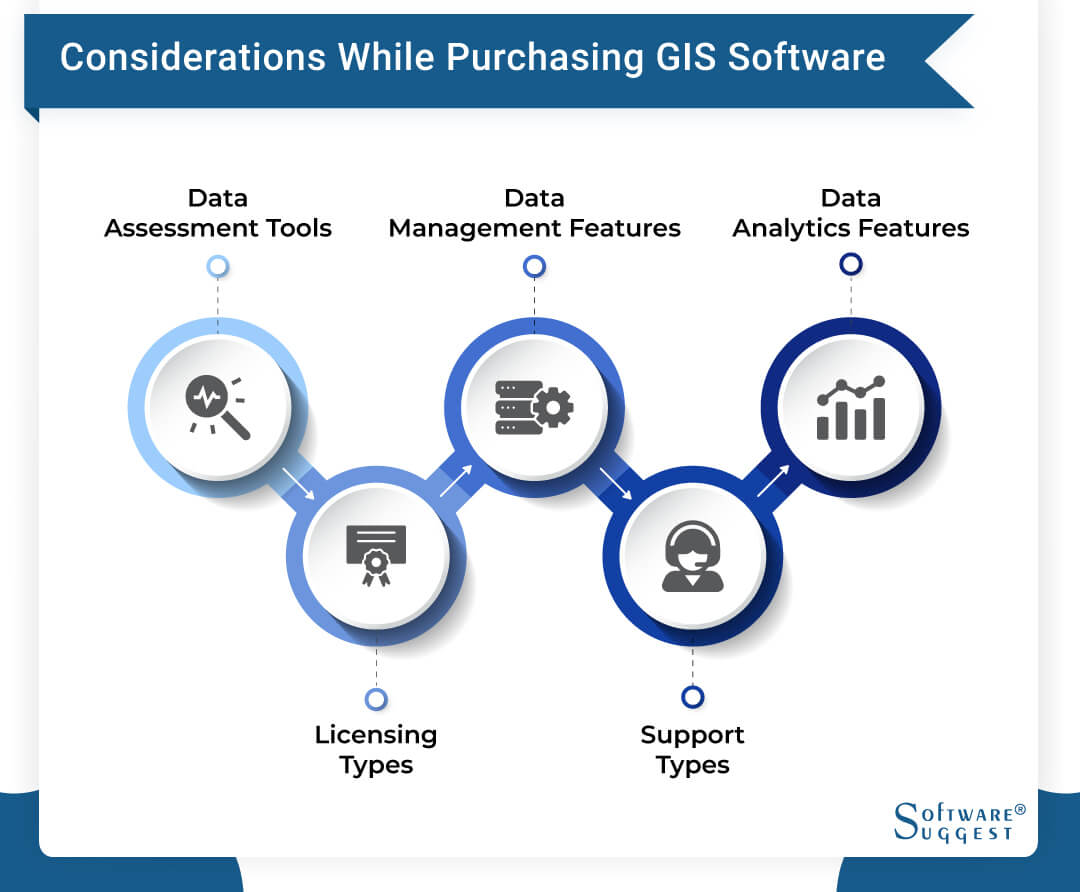
Here is a quick guide to read before purchasing geographic information system software including:
1. Data Assessment Tools:
It is vital to access your expectations from GIS software. It can be achieved by preparing a list of the mandatory tools in data assessment. It can also help to generate the required data sets on the GIS platform. Make sure that you only pay for what you will be using.
2. Data Management Features:
The scalability feature of GIS mapping software will be difficult to handle without the requisite data management features. Thus, these should be great integration options for time-to-time easy input and extraction of data.
3. Data Analytics Features:
The data analytics features of a geographical system will result in the best visualization. Thus, it is essential to look out for these features. The usability of your GIS should remain high which is dependent on these features only.
4. Support Types:
Like other software, the GIS system also demands genuine support. With more and more people accessing the internet through mobile phones, your GIS must be mobile-friendly. The vector methods can help upgrade your mobile user experience. Staying on the desktop-based or web-based GIS can limit its functioning and can affect the user experience.
5. Licensing Types:
There is an option to choose from proprietary licensing or open-source GIS software. You can select open-source GIS software options that are ideal for basic GIS and are highly manageable.
Challenges Faced in GIS Tool?
Like other software, GIS tools are also prone to specific challenges like:
-
The requirements of hardware, software, and trained GIS managing professionals require high costs.
-
It isn’t easy to integrate the traditional data that is not loaded in the tools previously.
-
It isn’t easy to simulate GIS software data.
-
The data structure is complex and difficult to apprehend in project transformation and requires specially skilled professionals.
GIS Software Trends
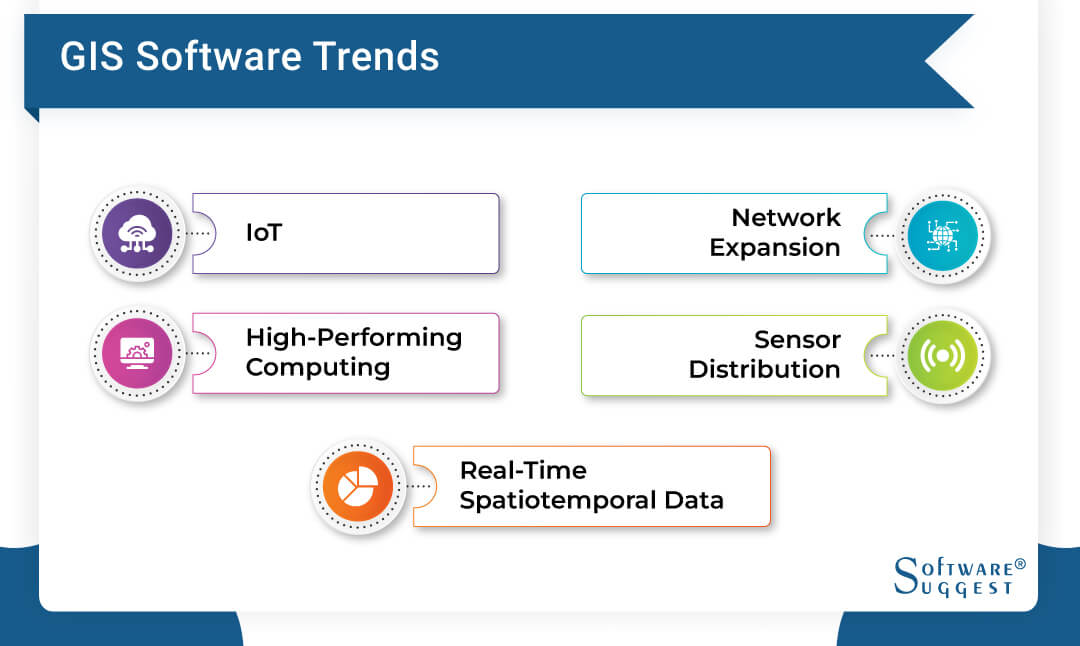
The future trends in GIS mapping software include:
1. IoT:
Internet of Things can help the miniaturization of hardware required in the proper functioning and implementation of GIS.
2. High-Performing Computing:
High-performing computing networks and cloud-based services allow quick access and high-end contribution to geospatial data.
3. Network Expansion:
Broad and quick access to wireless and web networks provide space for geospatial data distribution and data transmission.
4. Sensor Distribution:
The developments of new modalities for sensor distribution expand the working and benefits of simple GIS software.
5. Real-time Spatiotemporal Data:
The data collected across space and time is a revolutionary trend in cartographic representation and geography. It is a base of multiple GIS research initiatives.
FAQs
A geographical system’s principles start with input data processing, manipulation, proximity analysis, overlay analysis, and data visualization. Providing real-time inputs that are entirely based on geographic data for decision-making is the result of any GIS system.
GIS software can be used for many purposes depending on the organization’s sector. Shipment companies use it to track deliveries, government organizations to mark cities on different topics, and it can be used by insurance, retail, etc.
The GIS system’s primary purpose remains to be the mapping, analysis, querying, and visualization of data based on geography.
By Industries